ER2 Retrieval Simulation
Simulation of a measurement from the ER2 aircraft.
from ali.test.util.rt_options import simulation_rt_opts
from ali.retrieval.extinction import ExtinctionRetrieval
import numpy as np
import sasktran as sk
from ali.instrument.simulator import ImagingSimulator
from ali.atmosphere.curtain import SimulationAtmosphere
from ali.util.geometry import optical_axis_from_geometry
from ali.util.config import Config
from ali.test.util.atmospheres import simulation_atmo
from ali.test.util.sensors import simulation_sensor
import matplotlib.pyplot as plt
import os
from ali.atmosphere.gem import GEMAtmosphere
from ali.util.analysis import resolution_from_averaging_kernel, encode_multiindex, decode_to_multiindex
import xarray as xr
from ali.test.util.atmospheres import aerosol_cross_section
from ali.util.er2 import load_er2_data, er2_orientation
import matplotlib
matplotlib.use('Qt5Agg')
plt.style.use(Config.MATPLOTLIB_STYLE_FILE)
def basic_extinction_retrieval(clouds=False, lat=33.0,
mjd=54372, two_dim=True,
vertical_resolution: float = None,
test_file: str = None):
"""
Test retrieval of extinction using the ER2 sensor.
"""
np.random.seed(0)
# ------------------------------ ATMOSPHERE ----------------------------- #
altitudes = np.arange(500.0, 45001.0, 200)
atmo_sim = simulation_atmo(lat, mjd, altitudes, clouds=clouds, two_dim=two_dim, cloud_scaling=0.1)
# ------------------------------ GEOMETRY ----------------------------- #
er2_data = load_er2_data('21Jul2017-2045')
idx = 20000
er2_data = er2_data.isel(time=idx)
er2_geometry = er2_orientation(er2_data, instrument_pitch_deg=-4.3)
# ------------------------------ SENSORS ----------------------------- #
sensor_wavel = np.array([750.0, 875.0, 925.0, 1025., 1250.0, 1440.0, 1550.0])
exposure = [1.0] * len(sensor_wavel)
sensors = []
opt_geom = []
straylight = 0.0
for wavel, integration_time in zip(sensor_wavel, exposure):
sensor = simulation_sensor(wavelength_nm=[wavel], simulated_pixel_averaging=50,
image_vert_fov=5, image_horiz_fov=5.0,
noisy=True, vertical_resolution=vertical_resolution,
straylight=straylight, dual_channel=False, er2=True)
# sensor.exposure_time = integration_time
sensor.auto_exposure = True
sensor.max_exposure = 30
sensors.append(sensor)
# opt_geom.append(optical_geometry)
opt_geom.append(er2_geometry)
# ------------------------------ SIMULATOR ----------------------------- #
sim_opts = simulation_rt_opts(configure_for_cloud=clouds, cloud_lower_bound=5000.0,
cloud_upper_bound=18000.0, two_dim=two_dim)
simulator = ImagingSimulator(sensors=sensors, optical_axis=opt_geom,
atmosphere=atmo_sim, options=sim_opts)
# simulator.sun = geometry.sun
simulator.grid_sampling = True
simulator.group_scans = False
simulator.num_vertical_samples = 512
simulator.dual_polarization = True
simulator.save_diagnostics = True
measurement_l1 = simulator.calculate_radiance()
tanalts = measurement_l1[0].tangent_locations().altitude / 1000
retrieval = ExtinctionRetrieval(sensors, opt_geom, measurement_l1)
retrieval.aerosol_vector_wavelength = [750.0]
retrieval.max_iterations = 5
retrieval.vertical_samples = 512
if test_file is None:
test_file = os.path.join(os.path.dirname(__file__), 'data', f'test-er2-retrieval-{lat:.2f}-{straylight:.4f}.nc')
if os.path.isfile(test_file):
os.remove(test_file)
retrieval.output_filename = test_file
retrieval.simulation_atmosphere = atmo_sim
# retrieval.brdf = 0.65
retrieval.brdf = atmo_sim.brdf.albedo
retrieval.couple_normalization_altitudes = False
retrieval.use_cloud_for_lower_bound = False
retrieval.normalization_altitudes = [20000.0, 22000.0]
# retrieval.tikhonov_factor *= 0.5
retrieval.retrieve()
retrieval.plot_error(test_file)
plot_results(test_file)
def plot_level1(measurement_l1):
exp = np.array([float(m.data.exposure_time.values) for m in measurement_l1])
wavel = np.array([float(m.data.wavelength.values) for m in measurement_l1])
fig, ax = plt.subplots(1, 1, figsize=(5, 3), dpi=200)
fig.subplots_adjust(bottom=0.12, right=0.97, top=0.97)
ax.plot(wavel[0::2], exp[0::2], label='Vertical')
ax.plot(wavel[1::2], exp[1::2], label='Horizontal')
ax.set_ylabel('Exposure Time [s]')
ax.set_xlabel('Wavelength [nm]')
ax.set_ylim(0, 120)
ax.set_xlim(700, 1400)
leg = ax.legend(framealpha=1, facecolor=ax.get_facecolor(), edgecolor='none', fontsize='small')
leg.set_title('Polarization', prop={'size': 'small', 'weight': 'bold'})
tanalts = measurement_l1[0].tangent_locations().altitude / 1000
fig, ax = plt.subplots(1, 1, figsize=(5, 3), dpi=200)
fig.subplots_adjust(bottom=0.12, right=0.97, top=0.97)
color = plt.cm.Spectral
w0 = wavel.min()
w1 = wavel.max()
for idx, m in enumerate(measurement_l1[0::2]):
w = float(m.data.wavelength.values)
ax.plot(m.data.radiance, tanalts, color=color((w - w0) / (w1 - w0)), label=f'{w:0.0f} nm')
leg = ax.legend(framealpha=1, facecolor=ax.get_facecolor(), edgecolor='none', fontsize='small')
leg.set_title('Wavelength', prop={'size': 'small', 'weight': 'bold'})
ax.set_ylabel('Tangent Altitude [km]')
ax.set_xlabel('Radiance [photons/nm/s/st/cm$^2$]')
ax.set_xlim(0, 5e13)
ax.set_ylim(0, 22.5)
def plot_sensor(sensor):
wavelengths = np.arange(600, 1500.1, 10.0)
t = {}
for key in sensor._optics.keys():
t[key] = np.ones_like(wavelengths)
t['total'] = np.ones_like(wavelengths)
for idx, w in enumerate(wavelengths):
for comp in sensor._optics.keys():
t[comp][idx] = sensor._optics[comp].matrix(w)[0, 0]
t['total'][idx] = sensor.optics.matrix(w)[0, 0]
fig, ax = plt.subplots(1, 1, figsize=(5, 3), dpi=200)
fig.subplots_adjust(bottom=0.12, right=0.97, top=0.97)
for key in t.keys():
if key == 'total':
ax.plot(wavelengths, t[key], label=key, color='k', lw=1)
else:
ax.plot(wavelengths, t[key], label=key)
leg = ax.legend(framealpha=1, facecolor=ax.get_facecolor(), edgecolor='none', fontsize='small')
leg.set_title('Component', prop={'size': 'small', 'weight': 'bold'})
ax.set_ylabel('Transmission')
ax.set_xlabel('Wavelength [nm]')
ax.set_xlim(600, 1500)
ax.set_ylim(0, 1)
# ax.set_xlim(0, 5e13)
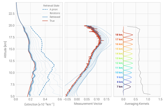
def plot_results(test_file: str = None):
if test_file is None:
test_file = os.path.join(os.path.dirname(__file__), 'data', 'test-er2-retrieval-33.00-0.0000.nc')
fig, ax = ExtinctionRetrieval.plot_results(test_file, aerosol_scale=1000,
kernel_kwargs=dict(ret_alts=np.arange(7, 35, 3),
fwhm_axis=False, alpha_scale=8))
ax[2].set_xlim(-0.4, 1.5)
ax[1].set_xlim(0, 0.85)
ax[0].set_xlim(0, 1.9)
ax[0].set_ylim(5, 35)
# ax[0].set_xscale('log')
# ax[0].set_xlim(1e-7, 0.5e-2)
# ax[0].set_ylim(5, 40)
fig.savefig(os.path.join(Config.DIAGNOSTIC_FIGURE_FOLDER, 'extinction-retrieval-scaled-cloud.png'), dpi=600)
fig.savefig(os.path.join(Config.DIAGNOSTIC_FIGURE_FOLDER, 'extinction-retrieval-test.pdf'))
if __name__ == '__main__':
# plot_results()
# resolution = np.linspace(0.001, 0.01, 10)
# for res in resolution:
# test_file = os.path.join(os.path.dirname(__file__), 'data', f'test-extinction-retrieval-{res:.4f}.nc')
basic_extinction_retrieval(clouds=True, two_dim=False, lat=33.0)